Denton Local History Society
Denton & Haughton in the Archive Photographs
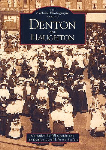 Denton and Haughton were two neighbouring towns until 1894 when Denton Urban District Council was formed, subsuming the township of Haughton and leaving the name Haughton Green. Durning the period covered by the book both towns were particulary famous for hatmaking but mining, farming and the cotton industry also dominated the working lives of the people in this area.
This sequence of over 200 old photographs shows some of these people in the settings of the streets and buildings in which they worked and lived. We see them at work and at play in peace time and at war. Most of these fascinating photographs have never been seen in print before. Included are some unique photographs taken by a gifted amateur Victorian photographer, Edward Joseph Sidebottom. These pictures record the area around Denton in the 1850's and also provide a pictorial account of the building of St. Annes Church, Haughton in the 1880's.
Denton Local History Society reaches it's twentieth birthday in 1998 and this collection of old images, which represents only a part of its large archive of photographs, documents and oral history records, helps celebrate two decades of reasearch in to Denton's history. The help of the people of Denton in putting together this archive over the years is greatfully acknowleged and the Society hopes that in turn the people of the town will now enjoy this pictorial representation of their community's history.
ISBN-13: 978-0752407579 - Price £11.99
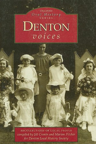
Denton Voices in the Oral History Series
 by Jill Cronin and Marion Pilcher for the Denton Local History Society
This book is extensively illustrated with contemporay photographs, largely chosen from the family albums of thepeople who were interviewed, and bring to life the memories that they accompany. The stories are sometimes amusing and sometimes poignant but all are an important record of a time gone by.
The book, compiled and published during 1998, celebrates the twentieth anniversary of the Denton Local History Society. The Society that it will servre, not only as a plesant and nostalgic read for older readers, but aslo help a younger generation to understand more about a way of life that was known to their parents and grandparents but which will seem far removed from their own. The text of this book is made up entirely of the memories of Denton people collected by the members of the Denton Local History Society on tape and transcribed onto the page .
The reminisences of over seventy people describe childhood, schooling, working in factories, shops and farms, wartime experiences and aspects of family and social life covering most of the century.
Memories of hatting, an activity now all but lost in Denton, are particually interesting because they describe in detail the skills and processes involved in an industry that was unitl recently the area's major employer. Terms like planking, stumping, blocking and trimming, and names like Wilsons, Wildes and Shaws are largely unknown by today's youth but only a generation ago were the topics of everysay conversation for these were the processes and employers in local hat making. Just as fascinating, too, are the accounts of life on local farms and in high street shops, the effects of wartime rationing and the pleasures of the Whit walks.
Kingswater: the Story Of Debdale
58 pages. Very well illustrated with maps, drawings and black and white plates. Debdale Vale is bounded by the townships of Audenshaw, Denton and Gorton and belonged originally to the Earls of Wilton and Stamford.
ASIN: B0016O3XPS
Denton Then and Now
Denton is one of the largest townships in the Metropolitan Borough of Tameside, largely because it now embraces the sister community of Haughton. In the early days of the industrial development, coal mining, cotton factoring and hat making were the key trades that brought work to the area and although the days of large scale manufacturing in Denton are over there is still evidence of those days to be seen. The remains of factory Buildings sometimes recycled for new uses, and the terraces of houses built for the mine and mill employees are still to be found.
Denton's early growth was aided by it's pivotal position at the important crossing of major routes but sadly this location has latterly brought about a devastating loss with the advent of the twentieth-century road developments. In the 1970s the construction of a new motorway, the M67, destroyed a large number of the town's residential and industrial buildings, schools and a church, a process that continued in the 1990s with the arrival of another motorway, the M60, which now meets the M67 in the west end of the town.
This book illustrates dramatically how these double invasions have changed the face of the town but also how much of the past, suprisingly, still survives. The Denton Local History Society selected a series of early photographs that show the old Denton as it was then took new photographs from the same vantage points to highlight the changes that have taken place. It is not only the buildings and the streets that receive attention: the people of Denton are seen as well, going about their everyday activities in the changing landscape. The accompanying captions provide a fascinating account of the background to the changes and the history of this important area. The book will appeal to all who knew the old town as it was but also to those who have recently and are only familiar with the new.
ISBN-13 / 9780752418391 £9.99
A History of the Pubs of Denton and Haughton
Written by Frank Rhodes in 1984, A4 is size and contains 32 pages, the book was published by Neil Richardson Publications.
Denton and Haughton are perhaps best known for the hatting trade which once thrived here, but way back in 1654 there where only 34 houses, with approximately 170 residents. By 1801 the population had risen to 1,362, with a corresponding increase in the number of inns. The new road from Manchester to Hyde, built in 1818, brought added prosperity to the township and so more licensed houses opened.
The 1830 Beerhouse Act, introduced to combat excessive gin drinking, facilitated the appearence of small, cottage beerhouses, which to some extent curbed the gin tipplers. In 1852 there were 10 public houses and 11 beerhouses in Denton alone, and in the following year there were 7 public houses and 7 beerhouses in Haughton. However, by 1871, with a slump in local trade, the total for both Denton and Haughton dropped to 15.
One hundred years later the number had risen to a staggering 31. The new road of 1818 brought new pubs but modern improvements to the roads in and around Denton, like the Denton relief Road, relieved Denton of quite a few amenities, including several pubs. However the areas of Haughton and Haughton Green are relativeley unscathed and the licensed houses still retain much of their old world charm. Many pubs have been modernised, but there are quite a few which retain the old Victorian and Edwardian fixtures and fittings - but all are worth the vistit.
Author Frank Rhodes Edition illustrated Publisher Neil Richardson, 1984 ISBN 090751135X, 9780907511359 Length 32 pages
Hats Off
(Currently Out of stock)
by the Denton Local History Society
The area, now named Crown Point North and lying between Ashton Road, the motorway and Taylor Lane, used to be the hub of the hatting industry of Denton, based on Wilton street. This book records that area in photographs, personal memories and descriptions of homes and buildings and their use. It brings to life residents, who worked in or owned the hat works and other businesses, attended Russell Scott School and Wilton Street Unitarian Chapel and socialised at the corner shops, the two local cinemas and the “Gentlemen's Club ”.
Denton Links - A History of Denton Golf Club
The History Of Denton Golf Club
BY ALAN WARD. PUBLISHED IN 2006
BOOK REVIEW BY DR F N VALDEZ
(Honorary Member, Past Captain, Past President Denton GC)
Alan Ward was born in Denton and became a Denton Golf Club member in 1964. The book was written as a prologue to the Club’s Centenary in 2009. It is of particular interest to the golfing membership since it is a comprehensive history of the Club from its foundation in 1909. Written in an attractive A4 format, the book contains 100 pages of text and over 150 photographs in black/white and colour. The subject matter covers both the geography and history of the 177 acres of land (leased by Manchester Corporation Waterworks) on which the golf course was built. Salient features along its boundary and within the course itself are described including Nico Ditch, Dodgeleach Brook and Cornhill Lane. The effect on the Club of the Kingswater Park proposal and the intrusion of the M60 Denton/Middleton Motorway are highlighted. Many other items of historical interest are portrayed including the bombing of the clubhouse in October 1940. Aerial photographs of the course can be seen at various stages of the Club’s history. For the members there are many special items of interest, all of which have contributed to making Denton Golf Club one of the finest in the area.
Without doubt, this interesting and well presented book is a must for all Golf Club members and anyone else interested in local history.
This book can be obtained from the Golf Club, Manchester Road, Denton, Thackeray’s Book Shop, Crown Point or dentonhistorysoc@aol.com
Price - £10.00
History of Denton and Haughton by Thomas Middleton
Currently we have no information on this publication.
From Chapel Into Church St. Lawrence's by John Ward
Currently we have no information on this publication, other than the ISBN numbers.
ISBN-13: 9780950348407
ISBN-10: 0950348406
Centenary History of St. Anne's School by Jill Cronin
St. Anne's, Haughton preserves a place-name which has all but disappeared from the modern map. How many people appreciate that orignally there were two townships, Denton and Haughton? Once Haughton, Haughton Dale and Haughton Green formed one township. Until, in 1894, Haughton joined Denton to form Denton Urban District Council, it was an independent town, rivalling Denton in size and population and relying, like Denton, on hatting, mining and cotton for its main occupations.
The Haughton strecthed from Audenshaw (North) to the River Tame (South and East) and Denton (West). Its name, spelt earlier HALGHTON and HALCTON, is old English in origin and means village (-ton) on peices of low-lying ground by a river (Haugh).
The area is recorded as early as 1307 in the Final Concords of the Country of Lancaster. Before St. Anne's was built, image a few rows of workers cottages along and adjoining Hyde Road, with a few scattered cottages amid the fields, ponds and farms stretching along the valley top.
The final indignity and death knoll for Old Haughton cane with the M67 motorway altering the valley and sweeping away most of the old houses and factories. Just a few houses survive of Haughton proper; it would be a shame if the township became hardly a memory.
Looking Back at Denton edited by Alice Lock
ASIN: B004Y46RWI
This book is not intended as a history of Denton, but to provide a glimpse of different aspects of the town's past. There is a range of contributions on different subjects and we hope this variety will provide something to interest every reader. Most of the contributors have made use of orignal documents and two have also used oral evidence showing the vast amount of useful material which can be gleaned from the memories of local people. Allan Arrowsmith and Joy Young show how much can be discovered from the limited range of text that exist from the early part of Denton's history.
The contents on the book are: John Anger The Angel on Horseback, Denton and Haughton in Tudor and Stuart Times, Hatting in Denton, Victoria Haughton, Coal Mining in Denton and Haughton and Shopping in Denton in the Early Years of the 20th C.
The origin of the town's three major industries, coal, cotton and hatting, can be traced back to earlier times it was the 19th century whichsaw their expansion. Evidence of Denton's past as a seperate and thriving town exists all around, in its industrial archaeology, in the document evidence and, not leaset, in the memories of its elderly. Many of the documents recording Denton's past have been preserved at the Tameside Local Studies Library.
Denton Town Centre 1918
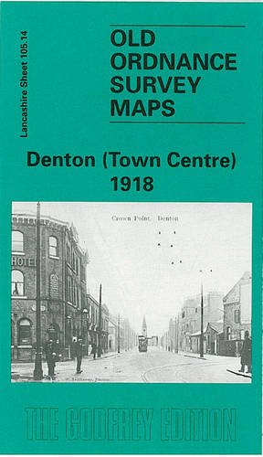 This detailed map covers the central area of Denton, with coverage stretching from Holland Street and Windmill Lane eastward to Kingston Mills; and from St Lawrence's church northward to Audenshaw cemetery. Features include tramways and depot, St Anne's church, Broomstair Bridge, River Tame, Peak Forest Canal, numerous small works such as hat manufactories, Victoria Iron Works, Market Place, Town Hall, Christ Church, Kingston Bridge, Broomstair Mill, Planet Foundry, Wellington Fur Works etc. On the reverse we include street directory entries for Acre Street, Ashton Road, Howard Lane and Hyde Road.
North Reddish including Denton SW 1904
Lancashire Sheet 112.01 This detailed map is dominated by Gorton Road which runs up the western side of the map, with coverage stretching from St Elisabeth's church and St Joseph's RC church northward to St Agnes church and Reddish station. Other features here include Summerfield House, tramways, Reddish Iron Works, Ashbrook Farm, Barlow Fold. Further east the map is semi-rural, with two railways, the LNWR Stockport to Guide Bridge line and Sheffield & Midland Joint line crossing in the centre of the map. Other features include Denton Colliery sidings and mineral line, Holt Wood, Dane Bank, Denton Hall. On the reverse we include a large extract from the later 1914 revision of the map, showing the Gorton Road area at this later date for comparison.
published 1994; intro by Jill Cronin. ISBN.978-0-85054-654-5
Denton and South Haughton Green 1904
This detailed map covers the area around and to the north of Haughton Green, with the Stockport Road area of south Denton to the north. Coverage stretches from Hyde Hall eastward to Gibraltar Mill on the River Tame. Other features include Denton cemetery, Great Wood Pit, Denton Colliery, Three Lane Ends, Vinery Hat Works, Town Lane, Moorfield Mills, St Mary's church, Whittles Farm etc. On the reverse we include a selection of street directory entries, incl Gibraltar Lane, Haughton Green Road, Stockport Road and Two Trees Lane.
published 1993; intro by Jill Cronin. ISBN.978-1-84151-051-4
Denton West 1916
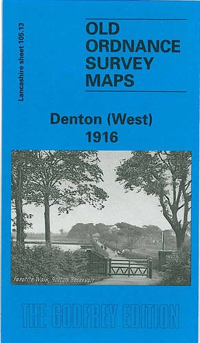 Lancashire Sheet 105.13
This detailed map covers the western part of Denton and coverage then extends westward to east Gorton around Gorton Bridge. Features include tramways, a stretch of the Manchester & Ashton Canal, Brook Green, short stretches of the GCR railway, cemetery, Gorton Upper and Lower Reservoirs, Lancashire Felt Works, a stretch of the LNWR line with Denton station, Audenshaw Reservoir Nr.2 etc. On the reverse we include street directory entries for Balmoral Drive, Heaton Street, Manchester Road, Oak Drive; plus a railway timetable for the Stockport-Stalybridge and Stockport-Manchester Victoria lines in 1897.
published 1996; intro by Jill Cronin. ISBN.978-0-85054-835-8